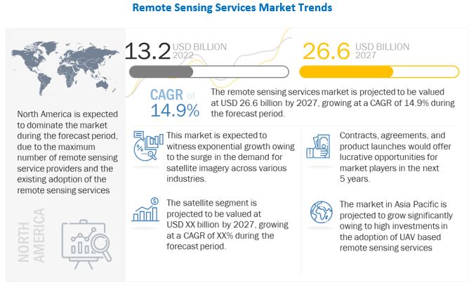
The report “Remote Sensing Services Market by Application, Platform (Satellites, UAVs, Manned Aircraft, Ground), End Use, Resolution (Spatial, Spectral, Radiometric, Temporal), Type, Technology (Active, Passive) and Region – Global Forecast to 2027” The Remote Sensing Services market is projected to grow from USD 13.2 billion in 2022 to USD 26.6 billion by 2027 at a CAGR of 14.9%. Remote sensing is gathering data about target objects that are not in direct contact with sensors. The sensors collect data through inputs using electromagnetic radiation or acoustical waves emitted by target objects. Remote sensing services include technical training for analysis, wherein service providers process and analyze the collected data for commercial and defense users and impart training to customers for equipment and operational knowledge.
• Informational PDF Brochure :- https://www.marketsandmarkets.com/pdfdownloadNew.asp?id=87605355
Browse 279 market data Tables and 48 Figures spread through 291 Pages and in-depth TOC on “Remote Sensing Services Market by Region – Global Forecast to 2027” View detailed Table of Content here – https://www.marketsandmarkets.com/Market-Reports/remote-sensing-services-market-87605355.html

Based on Application, Agriculture segment is estimated to be the fastest growing market
According to an article published by Gamaya, 37% of the planet is used for agriculture. Maintaining and improving efficiency in agriculture is one of the most overlooked challenges that humanity will face in the coming decades. As the population continues to grow, much of the world will depend increasingly on effective agriculture to output more resources that the world relies on.
The use of remote sensing systems such as satellites, UAVs, manned aircraft for precision agriculture can improve the yield per field using data-driven tools to monitor the health of crops. Satellite imagery can be used to provide a day-to-day analysis of crop status, enabling farmers to use remote sensing methods to identify problematic regions, optimize the application of nitrogen to the soil based on biomass assessment during multiple crop seasons, optimize water schedules, and run large-scale experiments.
Crop growth monitoring allows farmers to analyze fields, detect abnormalities, and track crop health in near-real-time capability. Satellite imagery helps farmers gain a time series vegetation analysis to better respond to changes in a crop lifecycle.
Based on platform, satellite segment is the largest
The potential application of a satellite remote sensing system to a specific field depends on the characteristics of the systems, such as the spatial, spectral, and temporal resolution of the onboard sensor. High spatial resolution is required for topographic mapping for relatively small areas. Likewise, high spectral resolution is crucial for precisely distinguishing between conditions of objects. Temporal resolution is important for repetitive observations, such as environmental monitoring.
Satellite remote sensing services are driven by the private sector’s investments in satellite imagery, growing mineral exploration, and the growing use of imagery data in a wide range of commercial and defense applications.
Satellites owned by private companies have played an unexpectedly important role in the war in Ukraine. For example, in early August 2022, images from the private satellite company, Planet Labs, showed that (opens in new tab) a recent attack on a Russian military base in Crimea caused more damage than Russia had suggested in public reports.
Asia Pacific likely to emerge as the fastest growing Remote Sensing Services market
The region is anticipated to be the fastest-growing market for remote sensing services. Geospatial analysis programs use raw remote sensing imagery and derive insights from it. Over the past decade, geospatial technologies have been used for rural and agricultural development in this region. Companies operating in various verticals, such as energy & power, engineering & infrastructure, agriculture, transportation & logistics, and maritime, use geospatial technologies to identify potential markets to enhance their growth prospects and undertake strategic decisions.
Geospatial imagery analytics play a crucial role in the agriculture sector, especially in India. Geospatial technologies assist in surveying and mapping crop plantations, increasing yield, optimizing resources, minimizing agricultural risks due to plant pests and climate variances, and improving farming practices.
Apart from the agriculture sector, these geospatial solutions are also utilized for city planning and development projects, thereby contributing to the growth of the remote sensing services market in the Asia Pacific region. For many years, Asia Pacific has been a region of great interest for renowned national space agencies.
Maxar technologies (US), Planet Labs PBC (US), L3 Harris Technologies (US), Airbus SE (Netherlands), Trimble, Inc. (US) are the key players in the global Remote Sensing Services market.
Media Contact
Company Name: MarketsandMarkets™ Research Private Ltd.
Contact Person: Mr. Aashish Mehra
Email: Send Email
Phone: 18886006441
Address:630 Dundee Road Suite 430
City: Northbrook
State: IL 60062
Country: United States
Website: https://www.marketsandmarkets.com/Market-Reports/remote-sensing-services-market-87605355.html

